G-Cans Project, Tokyo, Japan
World’s largest underground flood water diversion facility
The G-Cans project, Tokyo, Japan is a remarkable example of Critical Infrastructure (CI). The project (Shutoken Gaikaku Housui Ro, or the Metropolitan Area Outer Underground Discharge Channel) is a massive underground waterway and water storage area built by the Japanese government to protect Tokyo from flooding during the monsoon seasons. G-Cans, an engineering marvel, and unquestionably one of the most awe-inspiring wonder spots of Japan.
Begun in 1992, the two-billion-dollar project was completed in 2009. The tunnels run over 100 km, but perhaps the most impressive features of the drainage system are the 213-foot-tall silos and the 83-foot-tall, 580-foot-long pillared main tank known as the "Underground Temple," which was built to collect run-off from the city's waterways. The humongous drainage system can pump over 200 tons of water a second.
Background1
Population growth, urbanization, and global warming are the three most significant factors that govern global environmental change. It is estimated that in the next twenty-five years almost two billion or more people will move into cities. 95 percent of population growth occurs in developing world and it is estimated that the increase in built-up area in industrialised countries (from 300000 square kilometres in year 2000 to 700000 by 2030), and in developing ones (from 250000 square kilometres in year 2000 to 820000 by 2030).
Analysis of the above data suggests that urbanization in terms of global physical city area expansion (276% by year 2030) will happen much quicker than cities’ population growth (66% by 2030). This huge gap can be explained by urban growth in developed world, as well as rising living standards in developing world. Both: growth in built-up area and population growth imply a need to significantly expand UPI.
International Panel on Climate Change (IPCC) names the following effects caused by climate change: greater frequency of heat waves; increased intensity of storms, floods and droughts; rising sea levels; a more rapid spread of disease; and loss of biodiversity (IPCC, 2007). In the context of impacts on UPI extreme weather events and sea level rise (SLR) pose the major threats.
Recent data shows that SLR should be considered as some meters in the next 100 years. World Bank suggests that for precautionary planning purposes, SLR in the range of 1 to 3 meters should be regarded as realistic (Dasgupta et al 2007).
Nicholls, 2004, estimates that by 2080 up to 561 million people (under A2, 0.28 meter SLR scenario) could be living in coastal flood plains (area below 1 in 1000 year flood level). Mc Granahan et al, 2007, estimated that over 600 million people (360 million of whom are urban dwellers) are living in the less than 10 meters elevated above sea level coastal zone. Comparison of these two findings suggests that a number of populations in coastal areas affected during extreme weather events like flooding could be much higher than 600 million.
Currently almost two-thirds of the world’s cities with more than 5 million inhabitants fall in the 10 meter elevated zone, at least partly (Mc Granahan et al, 2007). Directly impacted by SLR urban land area constitutes 4.68 % of total world urban area in case of 5 meters SLR scenario (Dasgupta et al, 2007). However it is likely that over the years this figure will increase due to strong population growth in coastal zones, which is driven by urban sprawl, growing demand for waterfront properties and coastal resorts development (IPCC, 2007).
Coastal areas have quite high density of physical infrastructure. Gross Domestic Product (GDP) can be used as a proxy that reflects density of infrastructure. Coastal areas generate about 6% of World’s GDP on about 1% of the area.
Urban Physical Infrastructure1
Infrastructure includes 'physical' (such as water, sanitation, energy, transportation and communication systems) and ‘institutional’ (such as shelter, health care, food supply, security, and emergency protection) components.
Urban Infrastructure (UI) is a vital component of a city; it includes utility and transport networks, water and flood management structures, underground networks, etc. Urban Physical Infrastructure (UPI) is presented by bridges, roads, pipelines, transmission networks, etc. UPI as a whole has two notable characteristics: interdependence and convergence. Both of these characteristics trend to increase during continuing UPI evolution (e.g. DTI Forersight, 2006). By UPI evolution we mean technological progress and increase in diversity and complexity of infrastructure as a whole.
 |
Interdependence means that service provided by one infrastructure is used by another infrastructure, rather than its end users. Example: electricity line provides power for telecommunication equipment as well as to households, who are end users of electricity but not the electricity for a telecommunication line. The above example illustrates functional interdependence. Physical interdependence means physical connections of structural elements of different infrastructures. Example: storm water sewers can be connected or adjacent to motor/rail transport tunnels. This physical interdependence increases vulnerability of both infrastructures to e.g. floods, accidents with chemical leakages, geotechnical failures.
Convergence means that several originally independent infrastructures or services converge into one physical infrastructure. Examples: (1) "triple play" offers, where the operator provides at the same time via one cable telephony, internet and access to broadcast services (Infrastructure to 2030, 2006); (2) urban underground collectors, which include sewer, electricity lines, and water pipes; (3) a storm water management and road tunnel in Kuala Lumpur, Malaysia, which normally functions as a double deck motorway, however during flash floods the tunnel is closed for traffic and functions as a storm water collector (SMART Project, 2006).
The Location
Located on the outskirts of Tokyo, behind a small government building, underneath a soccer field and skateboard park, is an incredibly huge storm sewer system, built to protect the city's 13 million residents from heavy rainfall and tropical storm floods. The official name of these long, underground tunnels is the "Metropolitan Area Outer Underground Discharge Channel", but is more commonly called G-Cans. Built between 1992 and 2006, at the cost of $3 billion, this huge underground water management system comprises of 6.4 km of tunnels up to 50 meters underground connecting 5 giant silos, 65 meters tall and 32 meters wide, to one massive tank – the Temple.
G-Cans Project, or the Metropolitan Area Outer Underground Discharge Channel, is the world's largest underground flood water diversion facility. It is located between Showa in Tokyo and Kasukabe in Saitama prefecture, on the outskirts of the city of Tokyo in the Greater Tokyo Area, Japan.
The project aims to protect the city of Tokyo itself from floods during heavy rainfall and typhoons. The project operates by channelling the overflowing flood waters from the rivers within Tokyo to five silos through tunnels. The water is then stored in a huge storage tank and pumped out into the Edogawa River, which is located at a lower altitude on the outskirts of Japan's capital city.
Construction work for the $2bn G-Cans project started in 1992 and was completed in early 2009. The project was undertaken by the Japanese Government, guided by the Japan Institute of Wastewater Engineering Technology. The facility is capable of withstanding a once-in-200 years flood.
The Need
Tokyo witnesses frequent flood damage affecting the whole of the metropolitan area. The low-lying area in the east is the most affected. The Metropolitan Area Outer Underground Discharge Channel gathers the overflowing flood waters from rivers in Tokyo, such as Oochi Kotone, Kuramatsu, Nagakawa and Arakawa, and drains it into the Edogawa River.
The Saitama region, where the Edogawa River is located, is at the centre of the Kanto Plain in Japan. It is 20m above sea level. The Edogawa splits from the Tone River which passes through several cities before draining its water into Tokyo Bay. The G-Cans project starts at Showa in Tokyo and extends 6.4km towards Kasukabe in Saitama.
The Substructures
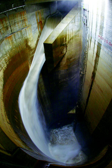
The project includes five huge silos, a 6.5km connecting tunnel, a storage tank and 78 pumps. The five concrete containment silos are 65m deep and 32m in diameter. They are located within certain limits from the rivers. The five silos act as flow regulators. The silos are connected to a 10.6m diameter tunnel. The tunnel is constructed 50m underground, passing through the silos. The tunnel sends the water to the storage tank when the silos reach their capacity.
The water storage tank, popularly called the Underground Temple, is 25.4m high and 177m long. It is supported by 59 pillars which are 20m tall and weigh 500 t. The tank is connected to 14,000 hp turbines and 78 pumps. The turbines are capable of pumping 200t of water a second and draining it into the Edogawa River. There is a control room within the tunnel and the storage tank. The facility remains dry during the dry seasons and serves as a tourist spot. The tunnel can be accessed through staircases fixed to the silos.
Tunnel construction
The tunnel was bored using the shield method in order to avoid distortions due to its depth. The essential idea of this technology is a reinforced solid frame to be pushed through a soft ground. This prevents the ground collapsing and allows for building a tunnel within the frame. Of course, mud and soil are excavated from the inside of the frame so that the building could start. The tunnel grows in length by repeating the process until the tunnel is completely built.
The work included excavation, construction of lining and muck transportation. The vast diameter of the tunnel also necessitated the application of a closed type slurry shield method. Modern technologies were applied for the secondary lining of the tunnel to cut the cost of construction. Water-tightness is maintained within the tunnel with the help of internal water pressure reacting type segments.
The Underground Temple
The "Underground Temple" is the most impressive feature of G-Cans that has been used as an atmospheric backdrop in various films and dramas. This giant metal reservoir measure 25.4 meters by 177 meters by 78 meters and is supported by 59 gargantuan pillars. Flood water from the city's waterways is collected through the tunnels and into the silos. When these fill, water from the silos works its way through a series of tunnels and into the massive "Underground Temple". From there, four turbines powered by jet engines, pump out 200 cubic meters or 53,000 gallons of water per second into the Edo River.
The utility of such a colossal drainage system is debated by some people. According to Tokyo's Central Disaster Management Council, if rainfall totaling 550 millimeters over three days hits Tokyo, causing the Arakawa river in Kita Ward to overflow its banks, then up to 97 subway stations would be flooded. That is however a once-in-200 year’s event, but one that G-Cans would help to drain away.
How Does it Work
The aim-to take all the excess rainwater from typhoons and floods away before it can cause any damage by building a massive drain. But the enormity and engineering complexity of the construction is staggering.
Step 1 - A series of 5 giant sinkholes has been dug into the ground, each designed to catch the runoff and overflow from nearby rivers. Each sinkhole looks something like the exit tunnel from the subterranean rocket base of a 1960s 007 James Bond villain. The sinks range up to 74m in height and 32m diameter. That’s big enough to house a Space Shuttle or one and a half Statues of Liberty with plenty of room to spare.
Step 2- During heavy rains and typhoons, tons and tons of flood and rainwater pours down these sinkholes and falls into the next engineering marvel - a giant concrete pipeline acting as an "underground river" which transports the water more than 6.3km through a tunnel 50m underneath the river basin.
Step 3
Finally the water reaches what is known as the “Underground Parthenon”, an incredible subterranean reservoir almost 180m long, 80m wide and 18m high. From here modified jet engine turbines pump the water out into the adjacent Edogawa (Edo River) at the phenomenal rate of 200 tonnes per second through sluiceways large enough to comfortably fit entire carriages of metro trains.All in all, the Water Discharge Tunnel on the Outskirts of the Metropolitan Area is estimated to reduce the potential flood impact on buildings, homes and urban areas by over 80%. Tested many times during high rainfalls and tsunamis over the last few years since completion, it has clearly proven its value. Levels of rainfall that previously devastated thousands of homes now affect less than a hundred.
References
- Urban Underground Infrastructure And Climate Change: Opportunities And Threats Nikolai Bobylev, Alexander von Humboldt Fellow; Berlin Institute of Technology and Russian Academy of Sciences
- http://japangasm.wordpress.com/2012/01/12/the-underground-wonder-of-tokyo/